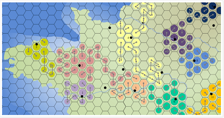
This method for quickly mapping fantasy kingdoms over on Coins & Scrolls is really neat.

Start with a blank map, just coastlines. Add dots for major settlements, and color the hexes around them to identify the “core regions” of different counties/duchies. Then roll dice to expand those counties, determine undeveloped regions, and create enclaves.
The end result looks dandy, but — perhaps more importantly — this mapping methods looks like a lot of fun and seems like it would produce a gameable map.

But why northwest France?
Easy way to grab a coastal outline, maybe?
Sacred blue! Name of a dog! Rover!
Southwest England has better curvy bits and coves and real pirate history. Penzance is a real place, as is The Lizard (bet you’d never expect to see a name like that outside of an RPG map) and the Cornish people were fond of “wrecking”. Yo-ho, Yo-ho, a Pirate’s life for me and all that.
Thanks for Coins & Scrolls by the way. One of the better RPG sites I’ve seen.